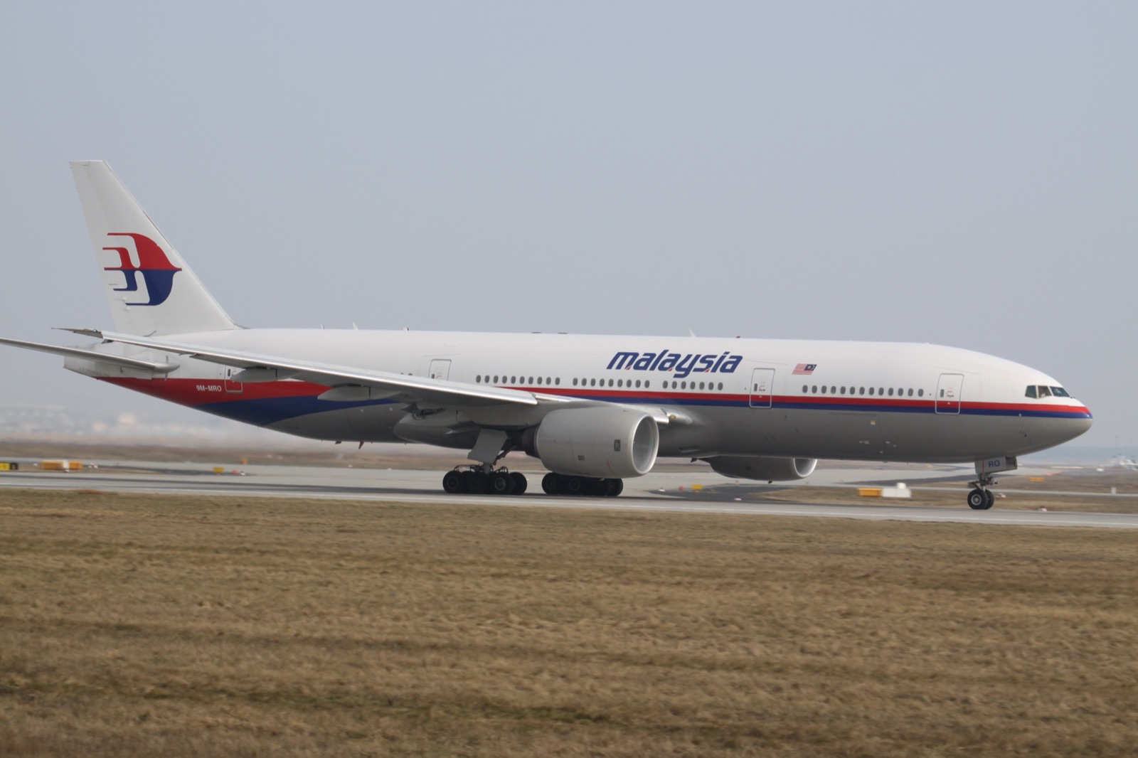
9M-MRO at Paris Charles de Gaulle, 2012. Two years later, this aircraft would disappear from radar over the South China Sea with 239 people on board. Photograph by Laurent Errera. Wikimedia Commons, CC BY-SA 3.0.
MH370
The plane that turned south
- Category
- Assassinations & Disappearances
- Published
- Length
- 3,650 words · 17 min read
- Author
- The editors
MH370
The plane that turned south.
The aircraft and the flight
9M-MRO was a Boeing 777-200ER, manufacturer's serial number 28420, delivered to Malaysia Airlines on May 31, 2002. By the time it operated MH370, it had accumulated 53,471 flight hours across 7,525 flight cycles — neither old nor new for a Boeing 777, which has a designed economic life of approximately 60,000 flight cycles. Its maintenance record was unremarkable. Its last C-check inspection had been completed February 25, 2014, eleven days before the disappearance, by Malaysia Airlines Engineering at Kuala Lumpur.
The flight crew was experienced. Captain Zaharie Ahmad Shah, 53, had been with Malaysia Airlines since 1981 — thirty-three years. He was a Type Rating Examiner and Type Rating Instructor on the 777. He had 18,365 flight hours total, of which 8,659 were on the 777. He was, by every measure available in the publicly released file, a senior pilot in good standing.
First Officer Fariq Abdul Hamid, 27, had been with Malaysia Airlines since 2007. He had 2,813 flight hours total. MH370 was his fifth 777 line check — the operational evaluation flight in which a junior first officer demonstrates competence to operate the type with a senior captain present. Had it gone normally, it would have been one of his last evaluation flights before being released to standard line duty.
There were ten cabin crew. There were 227 passengers, of whom: 153 were Chinese citizens, 50 were Malaysian, 7 were Indonesian, 6 were Australian, 5 were Indian, 4 were French, 3 each were American and Iranian, 2 each were Canadian, New Zealand, Ukrainian, and Russian, and one each held nationalities of Austria, Italy, Netherlands, Russia, and Taiwan.
The two Iranian passengers travelled on stolen Austrian and Italian passports. This fact emerged within days of the disappearance and fed early speculation about a terrorist attack. The pair were subsequently identified as Iranian nationals seeking asylum in Europe; no terror connection has been established in any subsequent investigation.
Timeline — Kuala Lumpur to the 7th arc
- 12:25 MYT
- Push-back from Gate C1, KLIA Terminal M. Final ACARS at gate.
- 12:41 MYT
- Takeoff runway 32R, KLIA. Climb to FL350 (35,000 ft).
- 01:01 MYT
- Reaches FL350. Lumpur Control clears direct to waypoint IGARI on filed route.
- 01:07 MYT
- Last automated ACARS performance report transmitted.
- 01:19:24 MYT
- Final voice transmission: "Good night Malaysia three seven zero."
- 01:21:04 MYT
- Transponder ceases — at the handoff boundary between Malaysian and Vietnamese ATC.
- 01:21–02:22 MYT
- Military primary radar tracks an aircraft turning sharply west, crossing the Malay Peninsula at FL340, threading the gap between Malaysian and Thai air defense, proceeding up the Strait of Malacca.
- 02:22 MYT
- Final military radar return — ~230 nm NW of Penang, at the edge of coverage.
- 02:25 MYT
- SDU re-logs onto Inmarsat I-3F1 satellite (3 minutes after last radar contact).
- 03:41 MYT
- Inmarsat handshake #2.
- 04:41 MYT
- Inmarsat handshake #3.
- 05:41 MYT
- Inmarsat handshake #4.
- 06:41 MYT
- Inmarsat handshake #5.
- 07:13 MYT
- Inmarsat handshake #6.
- 07:14 MYT
- Malaysia Airlines operations reports aircraft as overdue at Beijing.
- 08:11 MYT
- Inmarsat handshake #7 (final mathematical fix — the 7th arc).
- 08:19 MYT
- Brief log-on request and exchange — consistent with fuel exhaustion, engine flame-out, and APU restart. No further data.
The transponder
At 12:25 a.m. local time on March 8, 2014, MH370 pushed back from Gate C1 at Kuala Lumpur International Airport, Terminal M. It took off from runway 32R at 12:41. The takeoff was normal.
The aircraft climbed to its assigned cruise altitude of FL350 (35,000 feet) over the South China Sea on a route that would take it via waypoints IGARI and BITOD across the Vietnamese ATC sector boundary, then north over Vietnam, China, and into Beijing.
At 1:01 a.m., MH370 reached FL350 and was cleared by Lumpur Control to proceed directly to waypoint IGARI on its filed flight plan.
At 1:07 a.m., the aircraft's Aircraft Communications Addressing and Reporting System (ACARS) transmitted its routine 30-minute performance report to Malaysia Airlines operations. This was the last automated transmission. The next scheduled ACARS report at 1:37 was never sent.
At 1:19:24 a.m., the cockpit made its final voice transmission to Lumpur Control:
The transmission was a standard ATC handoff acknowledgment. At 1:21:04, less than two minutes later, the aircraft's secondary surveillance radar transponder ceased transmitting. The aircraft disappeared from the controllers' screens.
Vietnamese ATC, which was waiting to acquire MH370 as it crossed into its sector, never made the acquisition. They tried to contact the aircraft repeatedly between 1:38 and 2:03 a.m. There was no response. They notified Kuala Lumpur. Kuala Lumpur — operating under the assumption that the aircraft was now in Vietnamese airspace — initially assumed it was Vietnam's responsibility.
Four hours of confusion followed. Malaysia Airlines operations, unable to reach the aircraft through its own communications channels, reported the aircraft as overdue at Beijing at 7:14 a.m. By 7:24, news outlets were reporting that the aircraft was missing.
What the radar saw
What the civilian ATC screens lost at 1:21, military primary radar saw. Primary radar — which doesn't require a cooperating transponder on the aircraft, only a radar reflection — continued to track an unidentified return.
The Royal Malaysian Air Force radar facility at Western Hill, on the island of Penang, tracked the return for 49 minutes after the transponder dropout. The return:
- Performed a sharp left turn (approximately 180°) over the South China Sea between waypoints IGARI and BITOD, taking it back across the Malay Peninsula on a south-westerly heading.
- Crossed the peninsula at high altitude (approximately FL340).
- Threaded a 100-km gap between Malaysian and Thai air defense zones.
- Headed up the Strait of Malacca on a north-westerly heading.
- Last contact at 2:22 a.m., approximately 230 nautical miles north-west of Penang, at the edge of military radar coverage.
The Thai Air Force radar facility at Phuket also tracked a portion of the same return. The two radar tracks are consistent with each other.
The military radar tracks were not made public until three weeks after the disappearance. The Malaysian government, in the first week, publicly maintained that the aircraft had been lost over the South China Sea on its filed route. The military radar data, when released, fundamentally relocated the search area from the South China Sea to the Indian Ocean.
The Inmarsat handshakes
The radar track ended at 2:22 a.m. The next phase of the investigation rested on a category of data nobody had previously used for accident investigation: automated satellite communications handshakes.
The 777's Satellite Data Unit (SDU), used primarily for ACARS text messaging and Inmarsat voice service, automatically logs onto the satellite network when powered and periodically exchanges handshake messages even when no operational traffic is being exchanged. These handshakes — known as "pings" in the popular press, more accurately "log-on requests" and "handshake responses" — are not designed for tracking. They contain timing information (Burst Timing Offset, BTO) and frequency information (Burst Frequency Offset, BFO), but these were originally designed only for the network to maintain its connection quality.
MH370's SDU re-logged onto Inmarsat's I-3F1 satellite (positioned geostationary over the Indian Ocean) at 2:25 a.m. — three minutes after the last military radar contact. It then made handshake exchanges at 3:41, 4:41, 5:41, 6:41, and 7:13 a.m., before a final log-on request at 8:19 followed by a brief exchange and then no further data. The 8:19 sequence is consistent with a power interruption followed by automatic re-log-on — the kind of pattern that would result from fuel exhaustion and engine flame-out leading to an APU restart.
The BTO data, mathematically analyzed by Inmarsat, allowed the calculation of the aircraft's distance from the satellite at each handshake. This produced a series of arcs on the Earth's surface along which the aircraft must have been at each ping time. The final arc — the "7th arc" — became the search area.
The BFO data, more contestedly, allowed estimation of whether the aircraft was moving toward or away from the satellite, and at what speed. This analysis indicated the aircraft was moving south, fast, away from the satellite — eliminating the northern arc (over Central Asia and into China) and confirming the southern arc, into the Indian Ocean.
The search
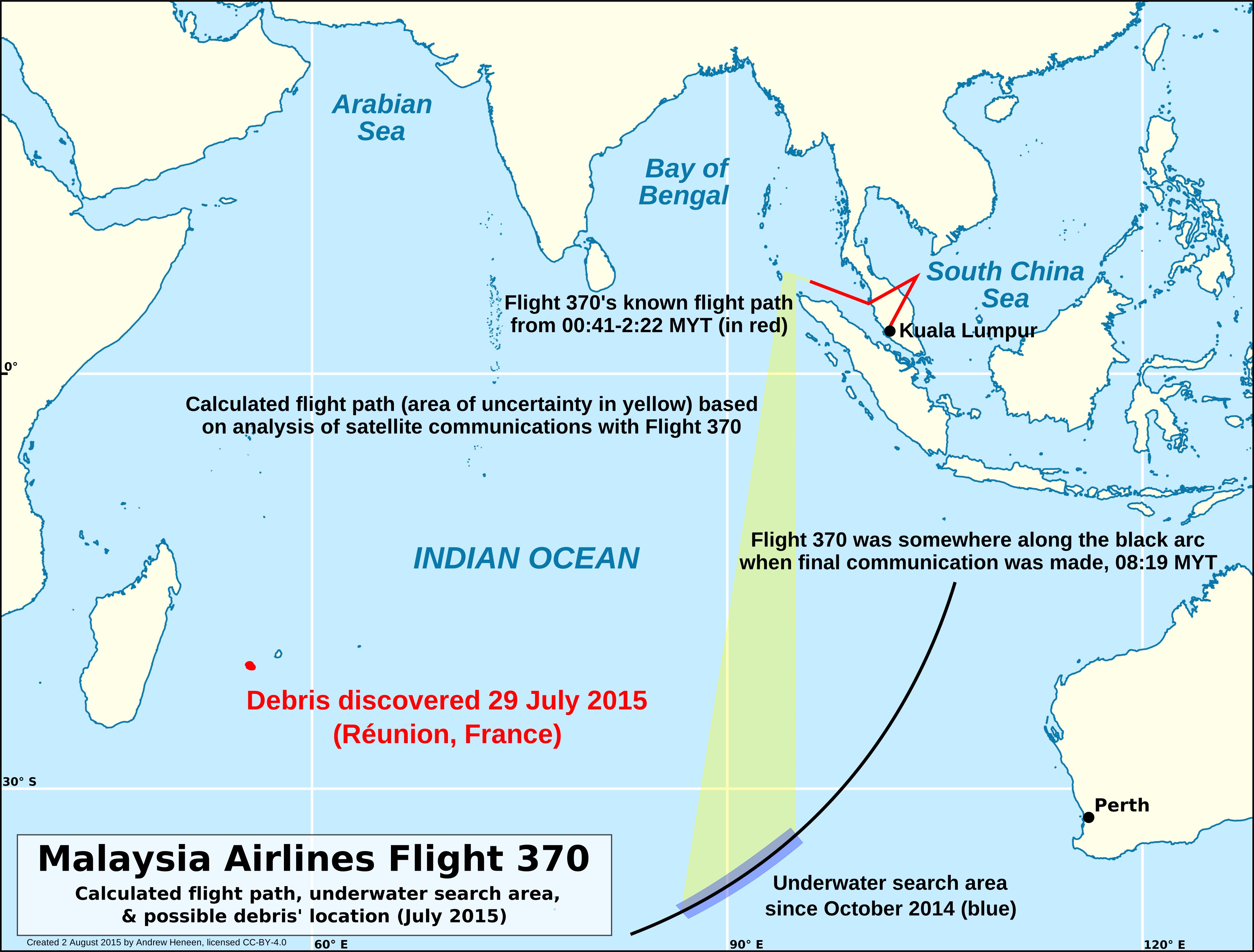

The southern Indian Ocean, where the search took place, is one of the least surveyed bodies of water on Earth. The seabed in the priority search area lies between 4,000 and 6,000 metres deep. The topography is rugged — fracture zones, abyssal plains, and seamounts — and was, before the MH370 search, mapped at approximately 5 km resolution from satellite-derived altimetry. The MH370 search produced, as a byproduct, the highest-resolution bathymetric map of the region ever made.
The Australian Transport Safety Bureau (ATSB), in coordination with Malaysia and China, led the search. Three phases:
Phase 1 (surface search): March 18 to April 28, 2014. Surface ships and aircraft searched approximately 4.6 million km² across the southern Indian Ocean for floating debris. Nothing was found.
Phase 2 (initial seabed search): October 6, 2014 to January 17, 2017. Three vessels — Fugro Equator, Fugro Discovery, and Go Phoenix — towed deep-sea sonar arrays across a designated 120,000 km² priority zone. Nothing was found.
Phase 3 (Ocean Infinity 2018): January to May 2018. The private seabed-survey company Ocean Infinity, contracted on a "no find, no fee" basis, conducted a follow-up search using eight autonomous underwater vehicles operating in parallel. They searched 112,000 km² in 121 days — by any prior standard, an extraordinary search- density. Nothing was found.
The combined searched area is approximately 232,000 km² — roughly twice the area of Iceland.
The debris
Beginning in July 2015, debris consistent with a Boeing 777 began washing ashore on western Indian Ocean coastlines.
The first piece — a wing flaperon — was found by a beachcomber on the eastern coast of Réunion Island on July 29, 2015, sixteen months after the disappearance. Forensic analysis at the French DGA laboratory near Toulouse confirmed within six weeks that it was from a 777, and that the serial number tied it to 9M-MRO. It is the only piece of debris that has been formally identified as "confirmed" 9M-MRO; the other 32 are classified as "likely" or "possible" based on materials analysis, construction patterns, and consistency with 777-200ER components.
Subsequent debris recovery locations:
- Mozambique (December 2015 and March 2016): two pieces, including a horizontal stabilizer skin section.
- Réunion (additional pieces, 2015-2016).
- South Africa (March 2016): a section of engine cowling.
- Mauritius (April 2016): a section of empennage.
- Tanzania (June 2016): a flap section.
- Madagascar (multiple recoveries 2016-2017, organized by independent investigator Blaine Gibson).
- Continued individual recoveries through 2024.
Drift modelling of where the debris landed, combined with reverse- drift simulations from current data, is consistent with origin along the southern part of the 7th arc — broadly between 30°S and 36°S, several hundred kilometres west of the Ocean Infinity search area's northern boundary.
What the Annex 13 report said
The Malaysian Annex 13 safety investigation released its final report on July 30, 2018 — four years and four months after the disappearance. The report ran to 495 pages with 1,494 pages of appendices.
The report's central conclusion: the aircraft was likely manually diverted (not lost to mechanical failure or autopilot anomaly). It made this conclusion based on the following:
- The transponder dropout occurred exactly at the Malaysian-Vietnamese ATC sector handoff, a timing consistent with deliberate selection of a moment of minimum surveillance.
- The 180° turn was executed at high precision, consistent with autopilot programming rather than mechanical failure.
- The route flown through the Strait of Malacca threaded military radar coverage in a manner consistent with deliberate avoidance.
- The Inmarsat handshake pattern indicated a flight that continued for hours after the diversion, ruling out catastrophic in-flight failure.
The report did not identify a specific perpetrator. It explicitly considered captain action, first officer action, hijacking, in- flight depressurization with hypoxia followed by autopilot continuation, and other scenarios. Of these, the report ruled out none with certainty, but treated deliberate diversion by someone in the cockpit (whether crew or non-crew) as the most consistent explanation.
The phrase "third party interference cannot be excluded" appeared in the executive summary. So did acknowledgment of the captain's home flight simulator and the simulator's recovered route data — addressed in a single short paragraph that has, in the years since, become the most contested part of the report.
The flight simulator
The captain, Zaharie Ahmad Shah, maintained a Microsoft Flight Simulator X installation at his home in Shah Alam, Selangor, with a custom multi-monitor cockpit setup. He had publicly posted videos to his YouTube channel demonstrating various simulator exercises. The simulator and its hard drives were seized by Royal Malaysia Police on March 9, 2014.
A police forensic analysis of the simulator's deleted-file recovery, completed in April 2014, identified a sequence of "ghost waypoints" on the hard drive — sequential GPS-coordinate way points whose path traced a route from Kuala Lumpur out toward the Strait of Malacca and then southward into the Indian Ocean, terminating in fuel exhaustion over the southern ocean.
The Malaysian police did not make this analysis public in 2014. It became public in July 2016 through a leak to New York Magazine's James Wallace. The Malaysian government, when asked, neither confirmed nor denied the leak. The Annex 13 report in 2018 acknowledged the simulator recovery in a single sentence, noting "a route to the southern Indian Ocean was found in the simulator's recovered data" but declined to draw an interpretation.
The simulator data does not, on its own, demonstrate that the captain piloted MH370 to its terminal location. A Type Rating Examiner with thirty-three years of flight time at a single airline might be expected to use a simulator to explore many routes, including pathological ones. The interpretation rests on whether the specific date proximity, the route specificity, and the terminal-fuel-exhaustion outcome of the simulator exercise are too specific to be coincidental.
What we still don't know
After eleven years of investigation, several questions remain materially unresolved:
The crash location. The 7th arc is approximately 4,300 km long. The southern portion has been searched comprehensively in the most likely band; the aircraft is not there. Either the southern band's boundary estimates are wrong (it crashed slightly outside the searched area), or the BFO analysis is wrong (the aircraft did not go south), or the BFO is right but the terminal behavior was a controlled glide rather than a steep dive (giving a much wider possible terminal location). All three remain possible.
The cause. Deliberate pilot action remains the consensus most likely explanation among investigators, but the evidence is circumstantial. Hypoxia incapacitation followed by autopilot- continued flight remains possible. Hijacking remains possible. Mechanical failure remains low-probability but cannot be entirely eliminated.
The state at terminal. Whether the final descent was a steep, high-energy impact (in which case debris would be concentrated near the 7th arc) or a controlled ditching (in which case debris could have travelled a long distance before sinking) affects search strategy fundamentally.
The captain's intent. The simulator data is suggestive. It is not dispositive. Without the cockpit voice recorder, no statement about intent can be made with high confidence.
Why this is a "mystery" case
MH370 is one of two commercial aircraft losses in the modern era (the other being Air France 447, June 2009, which was located after two years) where the primary wreckage location remained unknown for years after the disappearance. AF447 was eventually found, its black boxes recovered, and the cause definitively established. MH370 remains, eleven years on, unresolved.
The mystery is not about competing theories. The Annex 13 report, the Inmarsat analysis, and the debris drift modelling agree on the basic frame: the aircraft was deliberately diverted, flew for approximately seven hours on a south-westerly then southerly track, and ended in the southern Indian Ocean. Within that frame, the specifics remain open — and will likely remain open until a private or governmental search effort reaches the wreckage.
In December 2024, the Malaysian government and Ocean Infinity signed an "in principle" agreement to resume the search in 2025, with a revised search area informed by drift modelling and revised BFO analysis. As of mid-2026, the resumption is in operational planning. The case file remains open.
The cast
Sources
Primary documents:
- Safety Investigation Report: Malaysia Airlines MH370 — Annex 13, Republic of Malaysia, July 2018. 495 pages plus 1,494 pages of appendices.
- Inmarsat plc, MH370 Definition of Possible Search Area, March 2014 (BTO/BFO analytical method publicly described).
- ATSB, MH370 — Search and Debris Examination Update, January 2017.
- ATSB, The Operational Search for MH370 (final report), October 2017.
- Ocean Infinity, Seabed Constructor 2018 MH370 Search Report, June 2018.
- Royal Malaysia Police, Forensic Analysis of Flight Simulator Recovered from Subject Residence, April 2014. Reported publicly via leak to New York Magazine July 2016.
Secondary investigative reporting: 7. Jeff Wise, The Plane That Wasn't There: Why We Haven't Found Malaysia Airlines Flight 370 (Kindle Single, 2015; updated 2020). 8. William Langewiesche, "What Really Happened to Malaysia's Missing Airplane," The Atlantic, July 2019. 9. Christine Negroni, The Crash Detectives: Investigating the World's Most Mysterious Air Disasters (Penguin, 2016). 10. Florence de Changy, The Disappearing Act: The Impossible Case of MH370 (Mysterious Press, 2021). 11. James Wallace, "Exclusive: Malaysian Officials Suspect Pilot of Flight 370 Planned a Suicide Mission," New York Magazine, July 22, 2016. 12. Geoffrey Thomas, Airlineratings.com, continuing MH370 coverage 2014-2024. 13. The New York Times, multi-correspondent coverage 2014-present. 14. Tony Abbott, A Bigger Picture (2020) — memoir of the Australian Prime Minister during the initial search, with extensive MH370 chapter. 15. Aviation Herald, real-time technical reporting through Simon Hradecky.
Academic / technical scholarship: 16. Iannello, Steel, et al., "Bayesian Methods in the Search for MH370" (Defence Science and Technology Group Australia / Springer, 2018). 17. Davey, Gordon, Holland, Rutten, & Williams (CSIRO), The Search for MH370 (Springer, 2016).
Corrections & updates
2026-05-26: First publication.
Inspired this / based on it
Louise Malkinson (Netflix) · ★ 6.4
Three-part documentary covering official investigation and competing theories.
Smithsonian Channel
First major broadcast documentary; released six months after the disappearance.
Christine Negroni
Aviation journalist; full MH370 chapter and comparative analysis with other unresolved cases.
Florence de Changy
Le Monde correspondent in Hong Kong during the disappearance; alternate-theory investigation.
Jeff Wise
Kindle Single; widely cited early synthesis of Inmarsat analysis for general readers.
National Geographic / Cineflix
Standard Aircrash Investigation episode treatment with full official-investigation reconstruction.
Filed under
- #mh370
- #malaysia-airlines
- #boeing-777
- #9m-mro
- #zaharie-ahmad-shah
- #fariq-abdul-hamid
- #inmarsat
- #indian-ocean
- #atsb
- #ocean-infinity
- #reunion
- #flaperon
- #annex-13
- #2014
- #malaysia
- #aviation-mystery
Click any tag for every article carrying it.
Continue reading

The Snowden Disclosures
In May 2013, a 29-year-old NSA contractor named Edward Snowden boarded a flight from Honolulu to Hong Kong carrying four laptops loaded with classified documents from the world's largest signals-intelligence agency. Over the following months, *The Guardian*, *The Washington Post* and *Der Spiegel* published material from those drives that revealed the architecture of post-9/11 surveillance — PRISM, XKeyscore, Boundless Informant, MUSCULAR. Within ninety days, the global conversation about surveillance, sovereignty, and the limits of state power had shifted. Snowden has lived in Russia since August 2013.
Operation Mockingbird
Between 1948 and the mid-1970s, the Central Intelligence Agency cultivated paid and unpaid working relationships with American journalists, editors, and publishers across every major U.S. news organization. The architect was an OSS veteran named Frank Wisner. He called the network the 'Mighty Wurlitzer' — a theatre-organ metaphor for a machine that could play many instruments from a single console. The full scope was confirmed by the 1975 Church Committee, expanded upon in Carl Bernstein's 25,000-word 1977 Rolling Stone investigation, and partly declassified since. What the records have not yet given up is the operational name everyone agrees was attached to it.

The Russian Sleep Experiment
On August 10, 2010, an anonymous user calling himself OrangeSoda posted a 1,200-word story on the Creepypasta Wiki. It described a Soviet experiment in which five political prisoners had been sealed in a sound-proofed chamber and exposed to a stimulant gas that kept them awake for thirty days. The story has no documentary basis. No declassified Russian archive contains anything resembling it. But over the next fifteen years it has become — to a significant fraction of the people who encounter it — historically true. This is the story of how a fiction acquires the texture of evidence.